GGU-2D-SSFLOW
 GGU-2D-SSFLOW
Modelling of steady-state groundwater flow in horizontal-plane, vertical-plane, axis-symmetrical, two-dimensional groundwater systems using the finite-element method
Capabilities:
- Powerful mesh generator with mesh refinement and mesh optimization
- Import of ASCII data for the finite-element mesh or the interpolation mesh
- Finite-element mesh coordinates can be imported from a table via the Windows clipboard
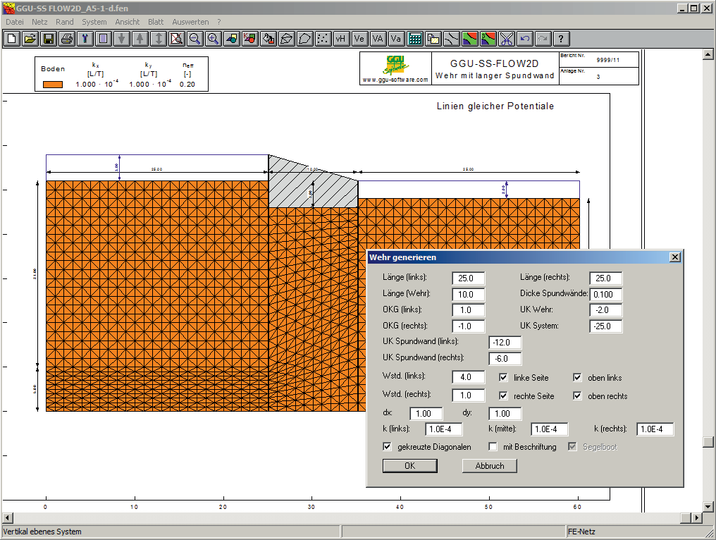
- Possibility of automatic generation of common finite-element systems (embankment, retaining walls, weir, wells, cut-off wall box)
- Definition of layer boundaries using fixed values or an interpolation mesh (ASCII data import from the GGU-GEO-GRAPH program)
- Graphics oriented data input and editor for fixed boundary conditions such as potentials and point, linear or area sources
- Proposal of standard values for the coefficient for determining the permeability in the unsaturated zone, kr = f(u)
- With it: possibility to manually change the values kr = f(u) by the user
- Evaluation of seepage lines taking into account the unsaturated zone
- Consideration of a horizontal plane system with a leaky aquifer
- Evaluation and presentation of potentials, velocities, gradients and discharge in user defined sections
- Evaluation and colored presentation of seepage velocities and gradients
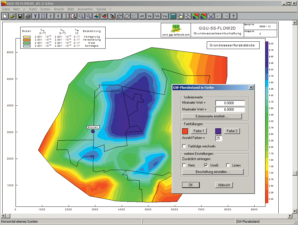
- Evaluation and presentation of groundwater thickness, depth to groundwater, confined areas and "dry" areas
- Evaluation and presentation of flow lines with distance and time increment
- Calculation of a differential contour diagram (for potentials) from two existing groundwater models and visualization as normal, color-filled or 3D contours
- Color supported presentation of results such as normal, colored or 3-dimensional contour lines, tables or circle diagrams
- Evaluation and presentation of velocities as vectors (arrows)
- Print output table with boundary conditions, potentials and sources
- Automatic transfer of steady-state data to the computer programs GGU-2D-TRANSIENT and GGU-CONTAM-FE/-RW for transient analyses
- Export of a pore water pressure mesh to the computer program GGU-STABILITY
- Interface for the computer program GGU-3D-SSFLOW (3-dimensional groundwater systems)
- User-defined design of output sheet
- Print or copy screen sections, e.g. for transfer to a word processor
- Integrated Mini-CAD system for additional annotation of graphics
Current updates & changes
12.2 (28.05.2026)
- Bug: Resolve overlaps in FEM2D mesh generation - also for nodes
12.1 (27.05.2026)
- Feature: Snap lines vs. snap line ends
- Bug: Tool Escape "delete" under mesh generation, possibly for other tools -> ESC key
- Bug: Legend is beneath the Minicad drawing objects:
- Feature: Perform various optimizations on the FE mesh
11.20 (10.12.2025)
- Bug: Mesh generation for rotationally symmetric wells
11.19 (05.12.2025)
- Bug: Limited number of elements in FE programs
- Feature: Mouse pan with middle mouse button in world coordinates
11.18 (08.09.2025)
- Feature: Update Check: Notification of new available versions and their contents
- Feature: Improve behavior of version notes box
Show all entries
Online-Shop:
All prices incl. VAT
Information about our licenses
Simple and secure processing!
During the further order process you switch to the store system of our technology partners "WIBU Systems" and "cleverbridge". You can find out more about these companies under the following links.
 |  |
Additional information:
System preferences
GGU-Software runs on PCs with the following specifications:
- Pentium III or higher processor
- Microsoft Windows® (SAC), 11, Server 2016, 2019 and 2022 compatible
- 500 MB free hard disk space
- DVD-ROM drive or internet connection (for installation)
- USB Interface 2.0 or higher (for licence CmStick dongle)
- CmActLicences NOT on virtual maschines
1.472,63 €
incl. VAT
365 days rent
- Free support
- Always current versions
- CmCloudContainer
- Supports virtual PCs
- Automatic license distribution
- Access via network/VPN
- Ends automatically
- Access for teams
981,75 €
incl. VAT
365 days subscription
- Free support
- Always current versions
- License binding to PC
- One program user
- Automatic renewal
- Annually cancelable
264,00 €
incl. VAT
10h PayPerUse
- All GGU applications included
- Free support
- Always current versions
- License binding to PC, CmCloudContainer or Dongle (CmStick with serial numbers starting with 3-344xxxx)
- Access via network/VPN
- Usage time by the minute
- All programs included
- Ends automatically
- Ideal for home office and license usage spikes
Webinars & Videos

Webinar
Export of the Potentials of a Steady-State Groundwater Flow Analysis from GGU-2D-SSFLOW to the programm GGU-STABILITY (33min)
To analyse the stability of slopes, the GGU-STABILITY program can be used to import pore water pressure meshes that were previously determined by means of a hydraulic analysis using the GGU-2D-SSFLOW program.
Welcome to the webinar to show you the export of the potentials of a steady-state groundwater flow analyses from GGU-2D-SSFLOW to the programm GGU-STABILITY.

Webinar
GGU-2D-SSFLOW Trailer (5min)
An overview of the potential of the computer programm GGU-2D-SSFLOW.

Webinar
Geotechnical Design of Earth Dams (78min)
Geotechnical Design of Earth Dams Using "State of the Art" Software
Sample Project: "Wippra"

Webinar
Flood protection with GGU-STABILITY und GGU-2D-SS-FLOW (29min)
Using examples, Dr. Peter Grubert shows how flood protection calculations are carried out with GGU-STABILITY & GGU-2D-SSFLOW.